


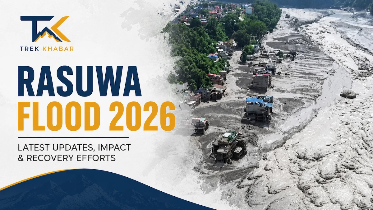
Quick answer: On the morning of August 26, 2026, an ice-rock avalanche broke off a glacier above the Nepal-Tibet border and slammed into the Lhende Khola, a river that feeds the Bhote Koshi. The debris briefly dammed the river; when that natural dam failed, a wall of water surged downstream through Nepal’s Rasuwa district and across the border into Tibet’s Gyirong County. As of the morning of August 27, more than 160 people are confirmed dead, hundreds remain missing — including foreign trekkers and pilgrims — and the disaster has destroyed the Gyirong-Rasuwagadhi border crossing, wiped out several hydropower stations, and shut down the Langtang, Gosaikunda, and Tamang Heritage trekking routes.
This is a fast-moving, still-developing story. Below is a complete, question-by-question breakdown of what happened, who it hit, and what it means if you’re planning to travel or trek in Nepal right now.
Rasuwa Flash Flood 2026 at a Glance
| Detail | Information |
|---|---|
| Event | Glacier/ice-rock collapse → landslide → flash flood |
| Date & time | August 26, 2026, ~8:37 AM NPT |
| Origin | Lhende Khola, ~20 km northeast of the Nepal-China border crossing |
| Rivers involved | Lhende Khola → Bhote Koshi → Trishuli River |
| Hardest-hit areas | Rasuwa district (Syabrubesi, Timure, Betrabati) |
| Deaths (confirmed so far) | 160+ across Nepal and Tibet, and still rising |
| Missing | Roughly 384 people, including 291 foreign nationals and 93 Nepalis |
| Trekking routes affected | Langtang Valley, Gosaikunda, Tamang Heritage |
| Border crossing | Gyirong-Rasuwagadhi crossing destroyed |
What Caused the Rasuwa Flood?
Nepal’s National Disaster Risk Reduction and Management Authority describes it as a “glacier-inclusive flood” that began when the lower section of a glacier broke away and crashed onto the valley floor, triggering a large ice-rock avalanche. That avalanche blocked the Lhende Khola, effectively building a temporary dam of ice, rock, and debris. When the blockage gave way, it released a sudden, high-force surge of water and sediment the kind of event known as a glacial lake outburst flood (GLOF).
The collapse registered on seismometers as a tremor of roughly magnitude 5.2. A smaller magnitude-4.4 earthquake had struck the same general area shortly beforehand, and Nepali officials initially floated the idea that the quake set off the avalanche. As of the latest updates, though, authorities on both sides of the border say the exact trigger earthquake, warming permafrost, or simple gravitational failure still hasn’t been confirmed. District officials did rule out one common culprit early on: there was no significant rainfall in the area at the time, so this was not a typical monsoon flood.
Satellite imagery from Planet Labs, reviewed by Reuters, shows the before-and-after starkly: forested, green mountainside replaced by a wide scar of brown debris and sediment.
How Did the Flood Reach Nepal’s Villages?
Once the dam failed, the surge moved down the narrow Bhote Koshi gorge at extraordinary speed. Reports indicate water levels in the Trishuli River rose by as much as 9 meters (about 27 feet) in just 30 minutes downstream. The flood tore through Betrabati, then hit Syabrubesi the main gateway town for northern Nepal treks and continued on to Timure, right at the border. From there it merged into the larger Trishuli River, carrying the danger zone well beyond Rasuwa itself.
Which Districts and Towns Were Hit?
- Rasuwa district — ground zero, with Syabrubesi, Timure, and Betrabati suffering the heaviest destruction
- Gyirong County (Tibet) — a mudslide on the Chinese side buried vehicles and buildings at Gyirong Port and caused additional deaths and missing persons
- Nuwakot district — communities along the Trishuli, including Trishuli Bazar, were flooded and placed under watch
- Dhading district — riverside areas warned to evacuate
- Gorkha and Chitwan districts — included in the downstream alert zone as the surge traveled south
How Many People Died or Went Missing?
The toll has climbed sharply through the day and remains provisional.
- Confirmed deaths: As of August 28 2026, More than 350 people across Nepal and Tibet combined, according to the latest reporting up from an initial count of around 95–100 confirmed on the day of the disaster. More dead bodies are being found, more being searched for the missing individuals.
- Missing: Nepal’s Tourism Board has cited roughly 384 people out of contact, including 291 foreign nationals and 93 Nepalis. Those missing include a large group of mostly Indian pilgrims (more than 100 people), a dozen Britons, and at least three Americans, along with travelers from Australia, the Netherlands, Malaysia, South Africa, Canada, Singapore, and Russia.
- Rescue response: Nepal has formally requested assistance from both India and China. Search and rescue is being slowed by destroyed roads, unstable slopes, limited helicopter access to the gorge, and continued high water in the rivers.
Officials on both sides of the border say they expect the confirmed death toll to keep rising as search teams reach areas that have been cut off since Wednesday.
What Infrastructure Was Destroyed?
- The Gyirong-Rasuwagadhi border crossing — a major trade and pilgrimage route between Nepal and Tibet has effectively been wiped out.
- Hydropower generation took a major hit: Nepal’s energy ministry says roughly 430 megawatts of capacity was knocked offline, about one-eighth of the country’s total installed capacity, as multiple hydropower plants along the Bhote Koshi were destroyed or badly damaged.
- Homes, shops, schools, and bridges in Syabrubesi and Timure sustained severe structural damage, with some multi-story buildings pulled off their foundations entirely.
- The Pasang Lhamu Highway, the main road link between Kathmandu and the Langtang/Rasuwa region, has partially closed, and public transit into the affected districts has been suspended.
Notably, this is the second time in about 14 months that the Lhende Khola–Bhote Koshi corridor has produced a destructive outburst flood: a July 2025 GLOF on the same river destroyed the (recently rebuilt) Nepal-China friendship bridge at Rasuwagadhi and killed more than a dozen people. Scientists studying the Hindu Kush Himalaya point to warming glaciers and thawing permafrost as reasons these mountain dam-burst floods are becoming more frequent.
Is the Langtang Trekking Region Affected?
Yes. Syabrubesi is the trailhead for three of Nepal’s most popular northern treks, all currently disrupted:
- Langtang Valley Trek — access through Syabrubesi is heavily damaged; trekkers already past this point toward Kyanjin Gompa are reportedly in a more stable, safer zone.
- Gosaikunda Trek — a significant number of trekkers were en route to this alpine lake circuit when the flood struck.
- Tamang Heritage Trail — shares the same disrupted access point and is currently paused.
Nepal’s Tourism Board has instructed anyone currently in the region to stay in safe locations, keep away from riverbanks, and wait for official clearance before continuing.
Is Nepal Safe for Travel Right Now?
Short answer: Yes, for the vast majority of the country. No, specifically for the Rasuwa/Langtang corridor near the Nepal-Tibet border, which remains an active disaster and rescue zone.
Kathmandu, Pokhara, the Everest (Khumbu) region, and the Annapurna region are operating normally and are not affected by this event. If your trip doesn’t route through Rasuwa, Syabrubesi, or the Gyirong border crossing, there’s currently no indication you need to change your plans.
If your itinerary does pass through the affected corridor:
- Postpone travel to Rasuwa district until roads and trails are officially confirmed safe.
- Avoid the closed sections of the Pasang Lhamu Highway.
- Do not attempt the Gyirong-Rasuwagadhi border crossing — it is destroyed and closed.
- Reconsider Langtang, Gosaikunda, or Tamang Heritage treks; ask your operator about Everest or Annapurna alternatives if your dates are fixed.
Alternative Route to Gosaikunda via Dupcheshwor
For trekkers looking for an alternative approach to Gosaikunda, the Dupcheshwor route from Nuwakot is worth considering. The route passes through Dupcheshwor, Ghyangfedi, Fedi and Suryakunda before reaching Gosaikunda, offering a quieter journey through rural villages, forests and high-altitude landscapes.
However, this route should not currently be treated as a safe bypass following the August 26, 2026 Rasuwa flood. Conditions can change quickly, and trekkers should wait for official confirmation that the roads and trails are open and safe before departing. Once cleared, the Dupcheshwor approach could be a useful alternative to the traditional Dhunche–Syabrubesi route.
Frequently Asked Questions
What triggered the Rasuwa flood of August 2026?
An ice-rock avalanche broke off a glacier and blocked the Lhende Khola near the Nepal-Tibet border. When that temporary debris dam failed, it released a glacial lake outburst flood down the Bhote Koshi. Whether an earthquake helped trigger the initial collapse is still under investigation.
How many people have died in the Nepal flood?
More than 160 people are confirmed dead across Nepal and Tibet as of the latest reports, and officials expect the toll to keep rising as rescue teams reach cut-off areas.
How many people are missing?
Roughly 384, according to Nepal’s Tourism Board — 291 foreign nationals and 93 Nepalis, including a large group of Indian pilgrims.
Is the Langtang Valley Trek currently open?
Access through Syabrubesi is disrupted and not recommended right now, though areas beyond Syabrubesi toward Kyanjin Gompa are reported as more stable. Confirm with a registered operator before departing.
Can I still travel to Kathmandu or Pokhara?
Yes. These areas are unaffected by the flood and operating on a normal travel schedule.
Is the Nepal-China border open?
No. The Gyirong-Rasuwagadhi crossing has been destroyed and is closed to all cross-border travel.
Has this happened before in this area?
Yes. In July 2025, a glacial lake outburst flood on the same river destroyed the Nepal-China friendship bridge at Rasuwagadhi. Scientists say warming glaciers make these events more likely to recur in the Hindu Kush Himalaya region.
This is a live, developing disaster. Casualty figures, missing-persons counts, and trekking-route conditions may change quickly. Always confirm the latest status with Nepal’s official tourism board or a licensed trekking operator before finalizing travel plans.
References
